


Ship Radar - Ship Positions

Deskripsi Ship Radar - Ship Positions
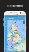
🌟 All vessels live on a map 🌟
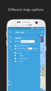
➡️ You have the option to choose between 4 map types: Standard map, Simple map, Satellite map or OpenStreetMap
➡️ Every vessel type is marked in a specific color
➡️ You can explore plenty of different vessel types: Fish carriers, Crude Oil Tankers, Fishing Vessels, Other Tugs / Special Crafts, Bulk Carriers, Fire Fighting Vessels, Service Vessels, Passenger Ships, Training Ships, Yachts and much, much more
➡️ Besides vessels, the map contains ports and other locations
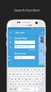
🌟 Search option 🌟
➡️You also have the option to search for specific vessels by IMO number or MMSI, ports, seas or other locations.
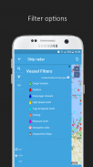
🌟 Filter option 🌟
➡️Sort out specific vessel types, so that you only get to see what you want to see.
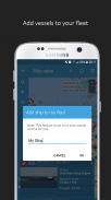
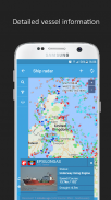
🌟 Vessel information 🌟
➡️ Get various pieces of vessel information by tapping on a vessel symbol such as speed, course and current status. You also get to see a picture of each vessel.
How does it work?
---------------------------------
We are using AIS data to provide you most accurate information. If you want to track vessels you just have to tap on "Start ship radar"
🌟 Semua kapal hidup pada peta 🌟
➡️ Anda memiliki pilihan untuk memilih antara 4 jenis peta: Peta Sederhana Peta Satelit peta Standard, atau OpenStreetMap
➡️ Setiap jenis kapal ditandai dengan warna tertentu
➡️ Anda dapat menjelajahi banyak jenis kapal: Ikan operator, Kapal Tanker minyak mentah, Kapal Perikanan, Lainnya Tugs / Kerajinan khusus, Bulk Carriers, Fire Fighting Kapal, Jasa Kapal, Kapal Penumpang, Kapal Pelatihan, Yachts dan masih banyak lagi
➡️ Selain kapal, peta berisi pelabuhan dan lokasi lainnya
🌟 opsi Pencarian 🌟
➡️You juga memiliki pilihan untuk mencari kapal-kapal tertentu dengan jumlah IMO atau MMSI, port, laut atau lokasi lainnya.
🌟 Filter pilihan 🌟
➡️Sort keluar jenis kapal tertentu, sehingga Anda hanya bisa melihat apa yang ingin Anda lihat.
🌟 informasi Vessel 🌟
➡️ Dapatkan berbagai potongan informasi kapal dengan menekan pada simbol kapal seperti kecepatan, tentu saja dan status saat ini. Anda juga bisa melihat gambar masing-masing kapal.
Bagaimana cara kerjanya?
---------------------------------
Kami menggunakan data AIS untuk memberikan informasi yang paling akurat. Jika Anda ingin melacak kapal Anda hanya perlu tekan pada "radar kapal Start"
Ship Radar - Ship Positions - Versi 1.1.9
(15-12-2020)
Ship Radar - Ship Positions - Informasi APK
Versi APK: 1.1.9Paket: com.sawischa.shipfinderVersi Terakhir dari Ship Radar - Ship Positions
Versi lain


Aplikasi pada kategori yang sama

Anda juga mungkin suka...
Aplikasi pada kategori yang sama


